

Lines, Wires, & Potatoes
Lines, Wires, & Potatoes
A bi-weekly collection of stories about climate infrastructure around the world
This is perhaps the best article on the internet about the internet. Written in 1996, it follows the “hacker tourist collective,” as it tracks the key information-infrastructure of the modern world like it is the last living whale.
(Perhaps it shouldn't come as a surprise this article is written by Wired, that has also covered sharks and wires, the Suez and wires, weather prediction and wires, etc.)
For those reading this newsletter on a Kindle, the internet is nominally the journey of how these words, from our fingertips, got broken down into thousands of light signals, traveled across hundreds of jurisdictions, visited dozens of rural server farms, got poured over by several national censors, and were displayed in your mail box… within milliseconds.
The Wired article begins with Samuel Morse, who stretched a wire between Washington and Baltimore in 1844, sending the first message, “’What hath God wrought!’—almost as if he needed to reassure himself and others that God, and not the Devil, was behind it.”
In the years following that first message, every modern city in the world was connected by a wire. As you might expect, “some of the early technologies were, in retrospect, flaky: one early inventor wanted to use 26-wire cables, one wire for each letter of the alphabet. But it quickly became evident that it was best to keep the number of individual wires as low as possible and instead find clever ways to fit more information onto them.”
Eventually metal became fiber, electricity became light, and different computing protocols were united under a single standard of TCP/IP.
The fundamental organizing aspect of wires — and all global infrastructure like time, rare earth commodities, currencies, shoe sizes, emojis, water, and energy — is standardisation. H2O and electrons are the same regardless of where you are on earth, but machines that process and display information on a screen or tools to measure atmospheric pressure are very different.
The world wide web is helpful in two regards. First, like the freeway, global telecommunication allows data about temperature variations, humidity, and chemical disturbances from across the world to instantly get computed in a single machine for a truly planetary understanding of the climate. Second, as a legal and technical endeavor, the internet is a perfect metaphor for how the world discovered climate change: by measuring, synchronizing, and standardizing environmental data.
“Over the last 160 years (the period of the historical thermometer records) practically everything about the weather observing system has changed — often,” said Paul Edwards in his book A Vast Machine. “Weather stations come and go. They move to new locations, or they move their instruments, or trees and buildings rise around them, or cities engulf their once rural environs.”
Edwards (who is the only historian that has ever been allowed to contribute to the IPCC report) noted that prior to the 1960s, the idea of climate change was impossible to comprehend because “It [was] like trying to make a movie out of still photographs shot by millions of different photographers using thousands of different cameras.”
Now, we can know the weather and what shoe size your favorite M&M wears, within milliseconds.

Imagine a city — sprawling, wide, divided by interconnected roads and organized into blocks. Now draw two parallel lines through that city and scoop up every house, road, building, and rogue biker and pile them all into the space between those two parallel lines.
Congratulations. You’ve just imagined a real city that Saudi Arabia is building.

The project, called “The Line,” is already manifesting in a desert in northwestern Saudi Arabia. The company building it is called NEOM and its website is almost as illusory as the idea itself. Upon entering the home page, you will immediately watch as a woman jumps from a typical gray urban-scape into a giant spinning silver flower, which brings her to a vertically layered green urban oasis where one can only expect that it’s always golden hour. (Seriously, click the link).
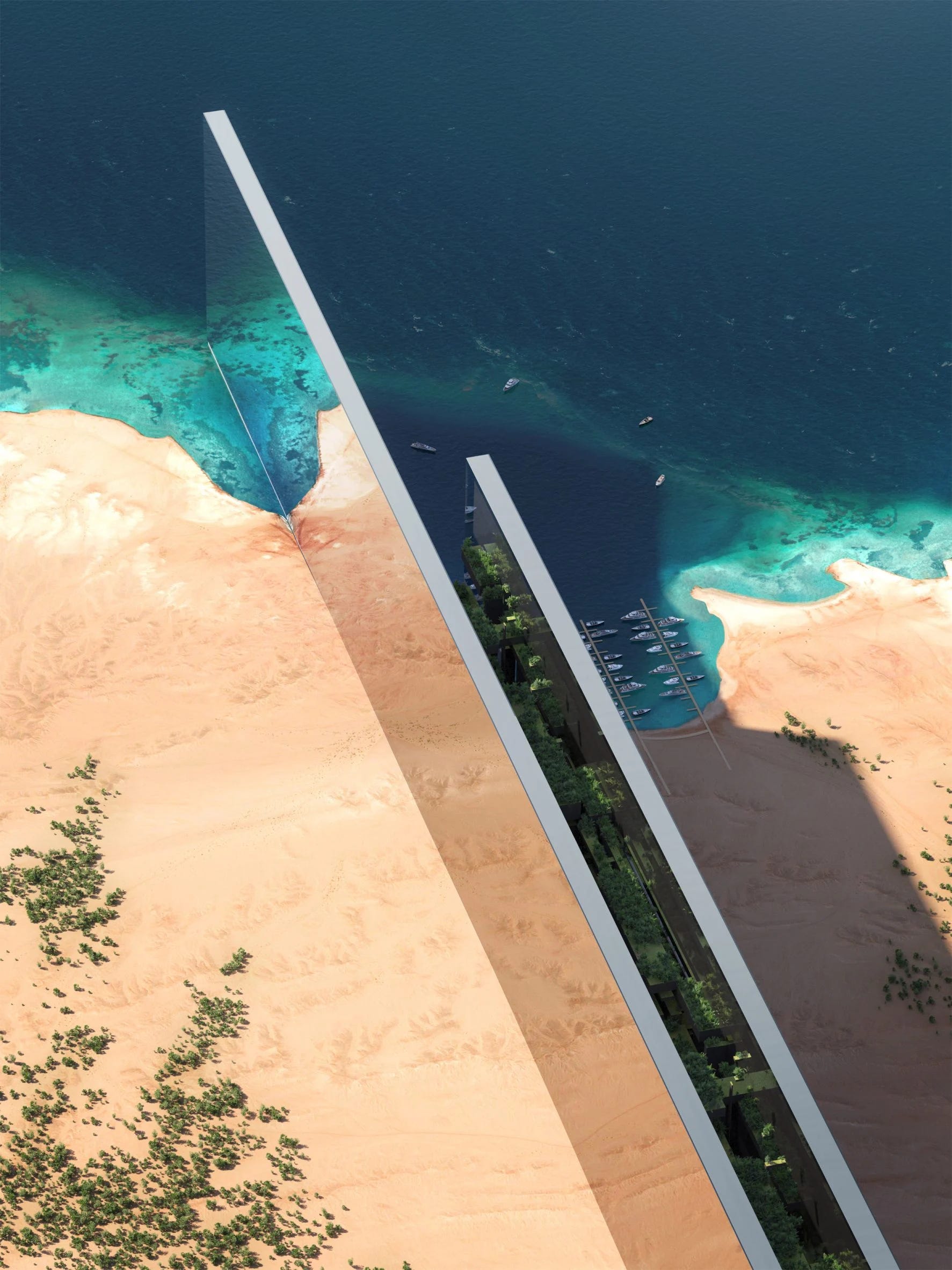
The Line was announced by Crown Prince Mohammed bin Salman of Saudi Arabia in 2021 and was advertised as a “civilizational revolution.” The goal is for it to house up to nine million people. The structure will in the shape of, you guessed it, a straight line. It will span 170 kilometers (105 miles), half a kilometer high (taller than the Eiffel tower), and just 200 meters wide (~218 yards). There are no cars, just underground trains and electric air taxis.
Costing at least $500 billion, the city will boast domestic robot servants, cloud seeding, and seawater desalination using renewable power. MIT Tech says “many of the technologies it is supposed to incorporate remain unproven,” referencing air taxis.
The concept of The Line is nothing new. In 1882, Arturo Soria y Mata called it “Ciudad Lineal.” In 1930, Nikolay Milyutin called it “Sotsgorod” (Sociality City). In 2012, Paolo Soleri called it “Linear City.”
Today it's “The Line.” In 50 years, it will be “Lin.” In 2200, it will be lower case “L.” In 2500 you might live in it.
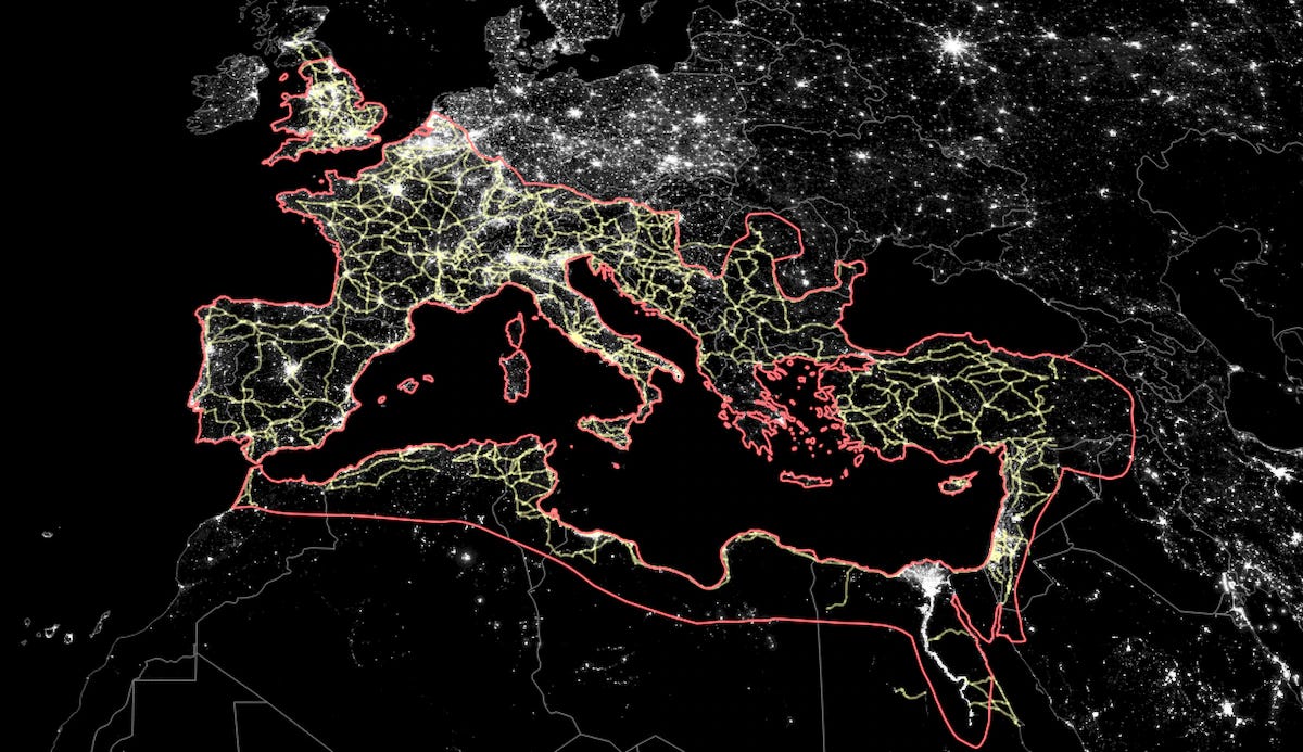
Danish economists superimposed the road network built by the Roman Empire and found that the richest cities in Europe still lie along this ancient pathway. Infrastructure is sticky.
“Roman roadways were massive infrastructure projects even by modern standards. They consisted of several base layers, including stone, gravel and sand, over which large stone slabs were laid. At the empire’s peak in 117 A.D., scholars estimate, the Romans had built more than 80,000 kilometers of roadway across Europe, the Middle East and North Africa. Many of them have lasted well into the present day...
Ancient Roman roadways are in light yellow, while the boundaries of the Roman Empire as of 117 A.D. are outlined in red. The background layer shows modern nighttime illumination.”
Senseable Lab at MIT put together an aesthetically pleasing visualisation of how 50 million individuals move within 235 Chinese cities. They mapped everyone's commuting pattern and found that while cities might expand in size, the individual commute time stays the same. In other words, people adapt to their living conditions so that average travel times remain stable. The resulting urban structure over time resembles a fractal, the pattern found in much of our planet’s natural organisms, hence MIT’s title “the Potato Project.”

Sierra Nevada’s glacial history is being used to help California balance flood and drought extremes. Over the last million years, powerful rivers dating back to the ice age divided the earth into channels and mountains until they formed, collectively, into what is now California’s Central Valley. As glaciers receded, gravel and rock covered the valley, forming an interconnected web of groundwater valleys that exist today — “paleo valleys,” as Scientific American calls them.
Scientists think that these “paleo valleys,” which are filled with gravel and therefore more porous, could be a space to store water. “People can restore hydrologic health by spreading water on the surface to percolate underground,” Erica Gies writes.
In other words, when storms hit and floodwaters give California all the water that it needed over the last two weeks of drought at once, these “paleo valleys” could store it for next time.